Difference between revisions of "DCOM Volume I Appendix K"
| Line 100: | Line 100: | ||
[[File:K1.JPG|729px|link=DCOM_Volume_I]] <br> | [[File:K1.JPG|729px|link=DCOM_Volume_I]] <br> | ||
| + | |||
| + | [[File:FigureK1.JPG|730px|link=DCOM_Volume_I]] <br> | ||
| + | |||
| + | '''K.5.2 Method No.2: Best Practice from FAO Experience'''<br> | ||
| + | Reservoir storage capacity can alternatively be estimated basing on field | ||
| + | experience of FAO as follows (FAO, 2010): | ||
| + | |||
| + | [[File:K2.JPG|728px|link=DCOM_Volume_I]] <br> | ||
| + | |||
| + | 6 is a factor (generally conservative) that can be adjusted (to 5 or 4) with experience | ||
| + | and local knowledge. All the parameters in method 2 can be determined by the | ||
| + | use of a level or theodolite (or any accurate GPS equipment) at the site. The | ||
| + | capacity estimated in this way is accurate to within about 20 percent, but it | ||
| + | must be revised by a more detailed survey when the site has been approved | ||
| + | for possible construction. The formula considers the water volume to be an | ||
| + | inverted pyramid with a triangular surface area (LT/2) and H/3 for the height/ | ||
| + | depth, and is a simplification of reality. With experience, one is able to judge fairly | ||
| + | accurately how an individual valley will compare with such an idealized picture | ||
| + | and therefore, to adjust the resulting conclusions (FAO, 2010). | ||
| + | |||
| + | '''K.5.3 Method No.3: Nelson Equation'''<br> | ||
| + | Nelson (1991) equation as cited by Nkuba (2009) is one of the recommended | ||
| + | equations for quick dam capacity estimations. | ||
| + | |||
| + | [[File:K3.JPG|732px|link=DCOM_Volume_I]] <br> | ||
| + | |||
| + | '''K.6 Preliminary Data Collection (Pre-design)'''<br> | ||
| + | K.6.1 Geotechnical Investigations<br> | ||
| + | In all major Civil Engineering projects, geotechnical investigations are important | ||
| + | in guiding designers on the most essential items to be considered. This important | ||
| + | item may only take 0.25 - 1% of the whole cost of the project. Such investigation | ||
| + | is required to give detailed information on the following aspects (Punmia et al., | ||
| + | 2010):<br> | ||
| + | (a) Water tightness of the reservoir Basin,<br> | ||
| + | (b) Suitability of the foundation for the Dam,<br> | ||
| + | (c) Geotechnical and structural features including; folds, faults, fissures, | ||
| + | lineaments etc., of the underlying rock at the site,<br> | ||
| + | (d) Type and depth of overburden (superficial deposit),<br> | ||
| + | (e) Location of permeable and soluble rocks, if any,<br> | ||
| + | (f) Ground water conditions in the region,<br> | ||
| + | (g) Location of quarry sites and other sources for materials to be used for dam<br> | ||
| + | construction and the estimated quantities of the intended materials,<br> | ||
| + | (h) Study of the geology for the catchment area as it has effects on the runoff | ||
| + | and percolations,<br> | ||
| + | (i) The geology of the dam site is important from the point of view that it secures | ||
| + | the foundation for the dam,<br> | ||
| + | (j) There should be special requirements for the geology of the reservoir site | ||
| + | such that there is no danger of serious leakage when the ground is under | ||
| + | pressure from the full head of water in the reservoir,<br> | ||
| + | (k) The nature of the sub surface geology should be explored by trial bores or | ||
| + | various means of geological explorations.<br> | ||
| + | |||
| + | '''K.6.2 Catchment Yield'''<br> | ||
| + | The total quantity of surface water that can be expected in a given period from a | ||
| + | stream at the outlet of its catchment is known as the "yield" of the catchment in | ||
| + | that period. In determining the catchment potential in yield to the dam reservoir, | ||
| + | some basic factors are usually considered. Such factors include catchment area, | ||
| + | catchment characteristics and the designed maximum flood expected to pass | ||
| + | through the spillway during extreme events. | ||
| + | |||
| + | '''K.6.3 Topographical Surveys'''<br> | ||
| + | This stage is executed when the site is suitable for dam construction and already | ||
| + | being confirmed against its potential to store enough water. Topographical | ||
| + | surveys will include contours generation after taking the ground levels as | ||
| + | per directed intervals by the Engineer. It is important to take the levels at the | ||
| + | reservoir area and locations of the spillway, other related infrastructure with the | ||
| + | dam, appropriate contours, and spatial arrangement of facilities with readable | ||
| + | scale. Propose survey control points for horizontal and vertical movements of the | ||
| + | embankment, baseline information, propose spacing and bench marks usually | ||
| + | away from the Tailings Storage Facility (TSF) embankment. Some of the relevant | ||
| + | and popular equations which may be used for volume computation include using | ||
| + | areas covered by the contours and those include the following: | ||
| + | |||
| + | [[File:K4567.JPG|725px|link=DCOM_Volume_I]] <br> | ||
Revision as of 10:07, 15 June 2021
APPENDIX K: DESIGN OF DAMS FOR WATER SOURCES
K.1 Introduction
In this Appendix, the following condensed information has been provided in order to assist design engineers to design dams that are expected to provide water for domestic use, to support livestock as well as for commercial and some industrial use. However, it should be borne in mind that the major water demand will be for domestic and livestock use. Furthermore, in Tanzania, majority of the existing dams for water sources are earthfill dams and only a few are rockfill dams. Furthermore, where a water source comes from a concrete dam, the primary purpose of that dam was for hydropower generation and hence the dam design is undertaken by the respective power generation agency. The Appendix has been broken into 20 sections that include:
- Types of Dams,
- Dam and Reservoir Pre-Surveys and Detailed Studies,
- Reconnaissance of Potential Dam Sites,
- Empirical Methods for Capacity Evaluation of Dam Construction Sites,
- Preliminary Data Collection (Pre-design),
- Designs of Earth-fill Dams,
- Height of the Dam,
- Design of the Embankment Filter
- Check of the Rip-rap Adequacy for the Safety of the Structure,
- Seepage and Stability Analysis of the Earth-fill Dams,
- Sediment Yield in the Catchment,
- Estimation of Evaporation from the Reservoir,
- Different Types of Spillways,
- Freeboard (Fb) Estimation,
- Estimation of Freeboard due to wave action (fwave),
- Embankment Crest Width (W),
- Embankment Slopes,
- Design Requirements for Tailings Storage Facility (TSF)
- Dam Break/Failure Analysis,
- Design Drawings.
K.2 Types of Dams
The general choice of a dam will depend to a large extent on the site selected for it. There are mainly three general types of dams that include:
- Earthfill dams which also includes rockfill dams;
- Concrete and Masonry dams;
- Sub-surface dams.
In the case of earthfill dams, the pressure exerted by their weight spreads over a much greater area by virtue of having flatter embankment slopes. A rockfill dam consists of an embankment made of stones of irregular sizes and shape faced either with concrete or masonry earth and clay. Concrete dams require foundations of much greater bearing pressure (strength) than earthfill dams which can be more easily constructed. A slight settlement in the foundation of a concrete or masonry dam may give rise to fractures whereas the same can often be well accommodated in the earth-fill dams. Technically, concrete dams are rigid structures while earthfill and rockfill dams are deformable structures. Because concrete dams are not common in water supply projects in Tanzania, no further discussion of these type of dams is presented in the manual.
Sub-surface dams are usually constructed by excavating a trench within the sand-bed of a river during the dry season which is then filled with impervious material that may or may not be zoned. Further design specifications of dams for water sources focus on earthfill dams. Rock-fill and earth-fill dams are usually built in relatively broad valley sites because large-sized machines can be operated efficiently in such sites. The selection of the dam type should be carefully made, firstly basing this on materials procurable at the dam site or in the neighbourhood, and secondly in case of fill type and where this can be found. Rain and temperature greatly affects the work period available.
A flood spillway is an indispensable part of any dam structure and therefore its size, type and the natural conditions involved in its layout often proves to be a governing factor in the selection of dam type. Because of the cost of spillways and the high sediment load in main watercourses, designers should always look at the possibility of off-channel storage sites on tributaries as these can often prove to be the more cost effective alternative, even though they often involve pumped storage.
K.3 Dam and Reservoir Pre-Surveys and Detailed Studies
Pre-surveys are required to be undertaken for each of the factors listed below. Subsequent to the pre-surveys, detailed studies have to be conducted on each of the following aspects:
a) Precipitation and reservoir evaporation
b) Inflow of sediments from main and any of the tributary rivers
c) Planned highest water levels
d) Watershed surroundings
e) Water quality
f) Topographical data
g) Geology of the area
h) Foundation characteristics
i) Preliminary location and hydraulic analysis of the spillways
j) Water demand and use conditions
k) Choice of the most suitable dam site.
K.4 Reconnaissance of Potential Dam Sites
A suitable site for a good reservoir shall depend upon the following factors:
a) Geological condition of the catchment area should be such that percolation losses are minimum and favors only maximum runoff.
b) The reservoir site should be such that quantity of leakage through it should be minimum. Reservoir sites having highly permeable rocks reduce water tightness of the reservoir. Good types of rocks that may not allow passage of much water includes shale, slates, schist, gneiss's, and crystalline igneous rocks such as granite.
c) The dam should be founded on sound, water tight rock base, and percolation below the dam should be minimum. The cost of the dam is often a controlling factor in selection of the dam site.
d) The reservoir basin should have a narrow opening in the valley so that the length of the dam is less.
e) The cost of real estate for reservoir including road, rail road, dwelling relocation, etc must be as little as possible.
f) The topography of the reservoir site should be such that it has adequate capacity without submerging excessive land and other properties.
g) The site should be such that a deep reservoir is formed. A deep reservoir is preferable to a shallow one because of:
- Lower cost of land submerged per unit of capacity,
- Less evaporation losses because of reduction in the water spread area,
- Less likely hood of weed growth.
h) The reservoir site should be such that it avoids or excludes water from those tributaries which carry a high percentage of silt in water.
i) The reservoir site should be such that the water stored in it is suitable for the purpose for which the project is undertaken. The soil and rock mass at the reservoir site must not contain any objectionable soluble minerals and salts (Punmia et al., 2010).
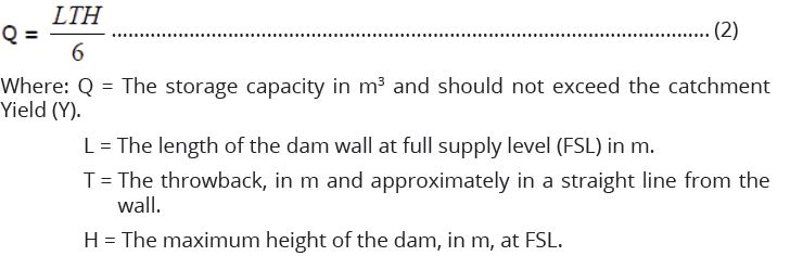
K.5 Empirical Methods for Capacity Evaluation of Dam Construction Sites
The cross sections of the proposed dam sites are usually plotted after acquisition of data from the field by using horizontal interval and the elevations taken by GPS during reconnaissance. The plotted cross sections will show that, there is a potentiality of building a dam of a certain type and at different heights and embankment lengths. The proposed dam sites may face different challenges including a small catchment area and hence poor water yield that can fill the dam, catchment degradation due to different human activities and hence sediment transport challenges along the river valleys. etc. All these challenges have to be well addressed during design. Usually the proposed dam sites have to be refined during detailed design phase as they may be shifted on either side downstream or upstream for appropriate dam axis setting with respect to appropriate dam heights and their capacities.
Through site verification, a number of potential dam sites can be identified and verified with their initial capacities being empirically computed. Three empirical methods may be used to make rough estimation of the reservoir capacities and these are illustrated as methods 1, 2 and 3 as described in the next paragraphs. The appropriate dam capacities will further be appropriately determined by using contours during the detailed survey stage of undertaking the project. Materials for construction (sand, gravel and stones) of such water storage facility are to be investigated and if possible to be cheaply and locally available within the project sites with clearly noted distance from the respective sites in-line with the specifications as presented in Chapter Twelve of the Volume I of the DCOM Manual.
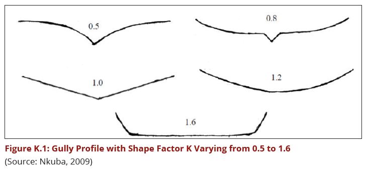
K.5.1 Method No.1: Queensland Water Resources Commission
Capacity for each dam site is estimated basing on appropriate empirical formula to get initial guess of the expected potential storage volume for each dam. The reservoir capacity is worked out based on empirical formula estimation as per the Queensland Water Resources Commission method (cited by Nkuba, 2009). The Commission developed a method which involves determining the shape of the gully/valley slice across section and then selecting a corresponding shape from a list each of which has its own co-efficient between 0.5 and 1.6 as illustrated in Figure K.1.
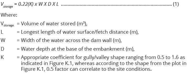
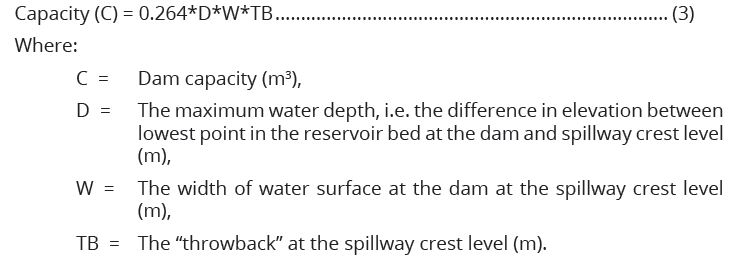
K.5.2 Method No.2: Best Practice from FAO Experience
Reservoir storage capacity can alternatively be estimated basing on field
experience of FAO as follows (FAO, 2010):
6 is a factor (generally conservative) that can be adjusted (to 5 or 4) with experience and local knowledge. All the parameters in method 2 can be determined by the use of a level or theodolite (or any accurate GPS equipment) at the site. The capacity estimated in this way is accurate to within about 20 percent, but it must be revised by a more detailed survey when the site has been approved for possible construction. The formula considers the water volume to be an inverted pyramid with a triangular surface area (LT/2) and H/3 for the height/ depth, and is a simplification of reality. With experience, one is able to judge fairly accurately how an individual valley will compare with such an idealized picture and therefore, to adjust the resulting conclusions (FAO, 2010).
K.5.3 Method No.3: Nelson Equation
Nelson (1991) equation as cited by Nkuba (2009) is one of the recommended
equations for quick dam capacity estimations.
K.6 Preliminary Data Collection (Pre-design)
K.6.1 Geotechnical Investigations
In all major Civil Engineering projects, geotechnical investigations are important
in guiding designers on the most essential items to be considered. This important
item may only take 0.25 - 1% of the whole cost of the project. Such investigation
is required to give detailed information on the following aspects (Punmia et al.,
2010):
(a) Water tightness of the reservoir Basin,
(b) Suitability of the foundation for the Dam,
(c) Geotechnical and structural features including; folds, faults, fissures,
lineaments etc., of the underlying rock at the site,
(d) Type and depth of overburden (superficial deposit),
(e) Location of permeable and soluble rocks, if any,
(f) Ground water conditions in the region,
(g) Location of quarry sites and other sources for materials to be used for dam
construction and the estimated quantities of the intended materials,
(h) Study of the geology for the catchment area as it has effects on the runoff
and percolations,
(i) The geology of the dam site is important from the point of view that it secures
the foundation for the dam,
(j) There should be special requirements for the geology of the reservoir site
such that there is no danger of serious leakage when the ground is under
pressure from the full head of water in the reservoir,
(k) The nature of the sub surface geology should be explored by trial bores or
various means of geological explorations.
K.6.2 Catchment Yield
The total quantity of surface water that can be expected in a given period from a
stream at the outlet of its catchment is known as the "yield" of the catchment in
that period. In determining the catchment potential in yield to the dam reservoir,
some basic factors are usually considered. Such factors include catchment area,
catchment characteristics and the designed maximum flood expected to pass
through the spillway during extreme events.
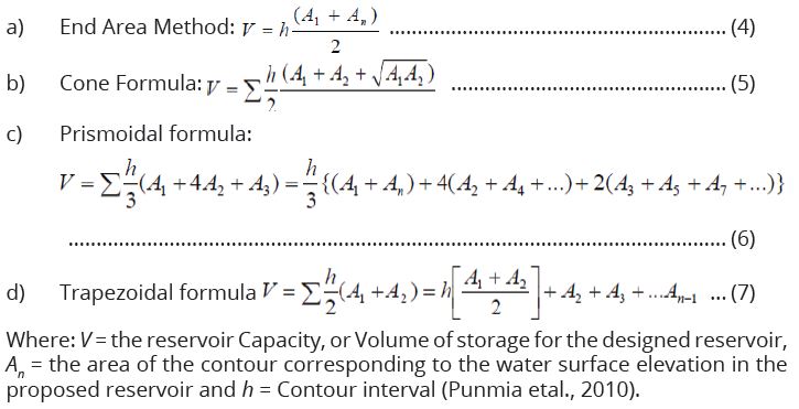
K.6.3 Topographical Surveys
This stage is executed when the site is suitable for dam construction and already
being confirmed against its potential to store enough water. Topographical
surveys will include contours generation after taking the ground levels as
per directed intervals by the Engineer. It is important to take the levels at the
reservoir area and locations of the spillway, other related infrastructure with the
dam, appropriate contours, and spatial arrangement of facilities with readable
scale. Propose survey control points for horizontal and vertical movements of the
embankment, baseline information, propose spacing and bench marks usually
away from the Tailings Storage Facility (TSF) embankment. Some of the relevant
and popular equations which may be used for volume computation include using
areas covered by the contours and those include the following: